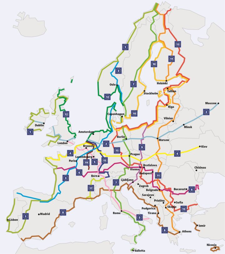
New figures show there are over 90,000 kilometres of EuroVelo routes to explore!

The EuroVelo network is made of 16 long-distance cycle routes, which connect and unite the whole European continent. The network was first established in 1995 and although there have been various attempts to measure and map the routes over the years, it has not been possible to do this systematically and accurately in all 38 countries through which the routes pass. Until now that is! Over the past year, the ECF’s EuroVelo team has reached out to all National EuroVelo Coordinators and Coordination Centres to get the latest tracks of the EuroVelo routes in their country – even those that are not fully realised yet.
Piecing together all the different tracks took some time, especially where the routes crossed national borders, but all this hard work has paid off allowing us to have a complete picture of the network and the tracks can now be easily updated going forward.
The biggest news is that thanks to this new data it is easier to calculate the total length of the network when completed. And the figure is higher than we previously expected! It now amounts to over 90,000 km adding up the lengths of every route, or around 85,000 km if duplicate routes (such as EuroVelo 10 – Baltic Sea Cycle Route and EuroVelo 13 – Iron Curtain Trail which both follow the same route along the southern Baltic Sea coast) are not taken into account. This makes EuroVelo the biggest cycle route network in the world!
Wondering which EuroVelo routes are the shortest and the longest? Take a look at the list below to discover the new official lengths of the EuroVelo network!
- EuroVelo 1 – Atlantic Coast Route: 11,000 km
- EuroVelo 2 – Capitals Route: 5,000 km
- EuroVelo 3 – Pilgrims Route: 5,300 km
- EuroVelo 4 – Central Europe Route: 5,100 km
- EuroVelo 5 – Via Romea (Francigena) : 3,200 km
- EuroVelo 6 – Atlantic-Black Sea : 4,450 km (6,250 km taking into account both sides of the Danube River)
- EuroVelo 7 – Sun Route: 7,700 km
- EuroVelo 8 – Mediterranean Route: 7,500 km
- EuroVelo 9 – Baltic-Adriatic: 2,050 km
- EuroVelo 10 – Baltic Sea Cycle Route: 9,000 km
- EuroVelo 11 – East Europe Route: 6,550 km
- EuroVelo 12 – North Sea Cycle Route: 7,050 km
- EuroVelo 13 – Iron Curtain Trail: 9,950 km
- EuroVelo 15 – Rhine Cycle Route: 1,500 km (2,400 km taking into account both sides of the Rhine River)
- EuroVelo 17 – Rhone Cycle Route: 1,250 km
- EuroVelo 19 – Meuse Cycle Route: 1,050 km (1,100 km taking into account both sides of the Meuse River)
Looking at the lengths of the EuroVelo routes per country, Germany takes the lead with over 9,800 km of EuroVelo routes, closely followed by France which has a total of around 8,600 km. Then comes the United Kingdom with over 6,000 km of EuroVelo routes coinciding with parts of the National Cycle Network.
The tracks have then been used to create the interactive maps on www.EuroVelo.com and on the official EuroVelo smartphone app (downloadable here for Android and here for iOS). The next big development they will lead on to is the new printed EuroVelo Overview Map, which gives an overview of the whole network in a poster format, indicating the level of development of each route. The updated version of this map is planned for March 2020 – but in the meantime, you can still download the 2016 version here.
All that is left now for you to do, is to calculate how many days you will need to cycle your next chosen EuroVelo route and to plan your trip!
Note that some of these figures are subject to change later on because parts of the network are still under development or at the planning stage. Visit our FAQ to know more about the route development status indicated by a legend of colour on the most detailed maps.
Author(s): Florence Grégoire, Ed Lancaster