Practical Information and FAQ
The aim of this "Practical information and FAQ" section is to provide general information on EuroVelo and how the quality of the routes is being communicated on the website
Contents
- Introduction & Definitions
- Development levels of EuroVelo Routes
- Follow the EuroVelo signs!
- Frequently asked questions (FAQs)
Introduction & Definitions
EuroVelo: Vision, Mission & Strategy for 2030
EuroVelo is the European network of long-distance cycle routes that cross and connect the whole continent. The development of EuroVelo will lead to safe, direct, coherent and connected cycling infrastructure and cycle route networks that will benefit all categories of cyclists. The network is developed and coordinated by the European Cyclists’ Federation (ECF), as one of its core brands and activities, in cooperation with a network of National EuroVelo Coordination Centres and Coordinators.
Our vision for EuroVelo is for a fully developed and high-quality European cycle route network, which is well-connected to national, regional and local cycle route networks and other sustainable modes of transport, driving further increases in everyday cycling and cycling tourism, in line with ECF’s vision to improve and increase cycling across the whole of Europe.
Our mission is to promote the further development of a sustainable, strong and well-connected European cycle route network, which:
- Acts as an accelerator to increase cycling;
- Drives change in European and national policies and practice;
- Benefits all categories of cyclists, including everyday cyclists, cycling tourists and leisure cyclists;
- Fosters sustainable tourism.
In the next decade, the main focus of EuroVelo network development will be on quality improvement, not on increasing the length of the network. We have tried to show on the interactive maps the current conditions that you are likely to experience when out and about. Four different development levels categories (see below) are used and are shown on the maps on this website, in the mobile application and on the printed EuroVelo map.
National EuroVelo Coordination Centres and Coordinators (NECCs)
The National EuroVelo Coordination Centres (NECCs) represent the link between the European and national levels of EuroVelo routes. Most of the time, it is a consortium of several national stakeholders – often including decision-making bodies on transport and tourism. They are responsible for the implementation, coordination, quality assurance and communication of EuroVelo in their respective countries.
The network of NECCs is continuously working on improving EuroVelo routes in their country, so you may find out that signage has been installed along certain sections; that more information is available online or that solutions have been found for some problematic sections. Keep checking this website for the latest situation along each route. For detailed questions concerning a national section of the EuroVelo network, it is possible to contact the relevant NECC. Contact details are available below the map on this page.
Development levels of EuroVelo Routes
The EuroVelo network is over 90,000 km long and includes 17 routes, each being over 1,000 km long. ECF is constantly working with its National EuroVelo Coordination Centres and Coordinators (NECCs) on developing the network but there remain substantial differences in the conditions of the routes (also between different sections on the same route). Whilst this is inevitable on a network of this size, it is important to communicate to potential users what they can expect if they cycle a particular section of a route. For this reason, ECF developed common development levels categories applicable to the entire network and communicated on the European level (on this website and on the printed EuroVelo Overview Map).
A bit of history
The first 12 EuroVelo routes were designated back in 1995 when the network was more an aspiration than a reality. Most of these routes have seen substantial development since then but there remains many sections at the planning stage or under development. Note that it is no longer possible for new routes, or extensions to existing routes, to join the network at this level of development, and EuroVelo routes that joined the network more recently (especially EuroVelo 14, 15, 17 and 19) are well developed overall.
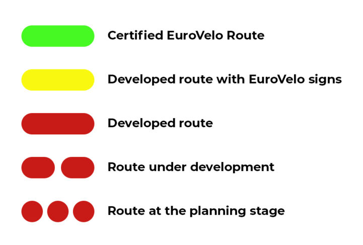
General development level categories and meaning of the map legend's colors

- Green lines indicate Certified EuroVelo routes, meaning that either the full route or a section of at least 300 km has successfully undergone the certification process in line with the ECF's European Certification Standard. It is the highest quality level on the EuroVelo network.
- Yellow lines indicate Developed routes with EuroVelo signs, meaning that the route is developed (see category below) and there is continuous signing along the route, incorporating EuroVelo route information panels.
- Continuous red lines indicate Developed routes at national/regional level, meaning that the route is developed for cyclists and signed in line with the respective national standard (i.e. it is part of a local, regional or national cycle network). There must also be a website providing information to users (linked to EuroVelo.com) for routes to be indicated as "developed".
- Dashed red lines indicate routes under development but usable. It means that it is possible to follow the route with detailed information publicly available on the internet on EuroVelo.com, and sometimes on national or regional cycling/tourism portals linked to EuroVelo.com. The route may contain some sections that need further development (e.g. stretches on public highways with high levels of traffic) and care must be taken when cycling there. It is sometimes advisable to use public transportation to skip these non-developed stretches, depending on the cyclist's experience and preferences.
- Dotted red lines indicate routes at the planning stage. These routes are not signed and there is no detailed information publicly available on the Internet. The proposed itinerary communicated is a proposal for the best possible option currently available. Please note that it may also contain dangerous sections. It is generally advisable to use public transportation to skip these non-developed stretches.
- Finally, white dotted lines show the public transport links, meaning sections for which another type of transport has to be used (mostly ferries and sometimes trains, and for some exceptions, planes due to ferry lines shut down). Please find more information on the stage and route pages.
The development status category selected for each section of the network is based on information provided by NECCs, and updated yearly to reflect the latest progress in the realisation of the routes and EuroVelo signage across the network. This progress is summarised once a year in the EuroVelo Route Development Status Report, the latest version of which can be downloaded from the EuroVelo Data Hub.
While ECF and National EuroVelo Coordination Centers (NECC) make every effort to ensure the tracks and their levels of development are both current and accurate, errors or outdated information can occur.
It is important to note that to join the EuroVelo network, a route does not necessarily have to be certified in accordance with ECF's European Certification Standard (ECS), a methodology designed by ECF to assess the quality of cycle routes and define minimum quality criteria that a route should meet. However, future EuroVelo routes joining the EuroVelo network will need to have been surveyed with the ECS methodology and to meet 90% of the ECS' essential criteria - i.e. they will need to have been verified in the field, and to meet all relevant criteria to be suitable for regular cycle tourists.
Follow the EuroVelo signs!
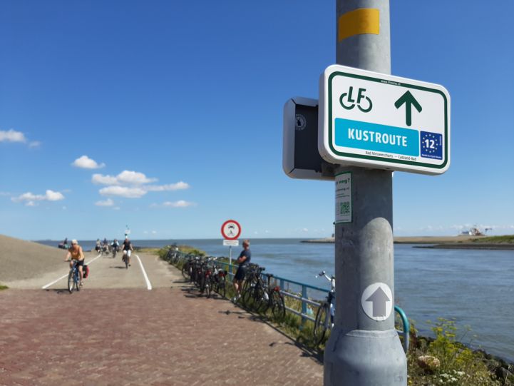
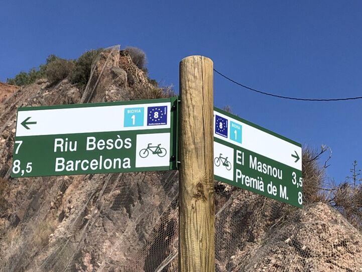
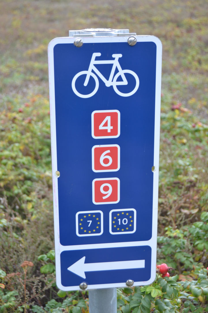
In more and more locations across the EuroVelo network, official EuroVelo signage is being installed to make your journey even easier. Just look out for the distinctive EuroVelo signs, which can be incorporated in several different ways. You can now follow the EuroVelo signs in 24 countries across Europe!
Countries featuring EuroVelo signs in 2023: Austria, Belgium, Croatia, Czechia, Denmark, Estonia, Finland, France, Germany, Hungary, Latvia, Luxembourg, Norway, Poland, Portugal, Ireland, Serbia, Slovakia, Slovenia, Spain, Switzerland, The Netherlands, Turkey and United Kingdom.
Below are a few examples of EuroVelo signs:


Frequently asked questions
Where can I find out what parts of the network are complete?
In many cases substantial sections of EuroVelo routes are already complete and signed, but gaps in high-quality infrastructure still exist. When you are on a EuroVelo route page, click on a stage (on the left or the map) or on a country (on the right of the map) to access detailed information about the route. On stage pages / country per route pages, the interactive map provides a colour-coded overview of the route itinerary. Yellow (developed with signs) sections are cycle routes with signposting in both directions. Red (realised) sections are cycle routes that are well developed and follow existing national or regional cycling itineraries, but have not yet been signed with EuroVelo signs. Dashed red (not realised) sections are undergoing work to meet EuroVelo standards but follow existing cycle infrastructure. Dotted red (planned) sections are still in the route planning phase.
More information on the categories of EuroVelo routes can be found above.
Where can I download GPS tracks of the EuroVelo network?
Since 25 July 2022, the GPX download feature is available on EuroVelo.com! When downloading EuroVelo GPX tracks please remember that it is required to read the disclaimer, which includes a description of the development statuses as well.
Keep also in mind that the EuroVelo network is organised as an umbrella focusing on EuroVelo at the European level, while a network of National EuroVelo Coordination Centres and Coordinators (NECC/Cs) take care of developing the routes at national and regional levels. The management of EuroVelo follows a subsidiarity principle, the EuroVelo website aiming to provide overview information about the whole 90,000km European cycle route network. Additionally, all EuroVelo routes are not at the same levels of development, and some sections of the European cycle route network are still at the planning stage.
Moreover, when browsing the EuroVelo route pages, you will find many links to national or regional websites managed by the NECC/Cs, which often provide also downloadable GPS tracks. However, please keep in mind that ECF is not responsible either for those.
We are aware that the downloadable EuroVelo GPX tracks are low quality at the moment, and we are working to solve this problem so that the tracks are sufficiently detailed to easily follow in the field. We are also working on improving the way EuroVelo GPX tracks are displayed on common routing softwares.
Where can I find maps and guidebooks?
You can ask to receive the printed map of the whole EuroVelo network and the services handbooks of EuroVelo 15 - Rhine Cycle Route and EuroVelo 8 - Mediterranean Route by making a donation to EuroVelo.
You can find also a list of "Maps & Guides" by clicking on the dedicated tab on each EuroVelo route page.
Maps of national or regional sections of the EuroVelo routes are currently available from many online sources including:
- France Vélo Tourisme: for cycle routes in France
- Le Routard: mainly in France and Belgium
- Bikeline cycling guides: mainly for cycle routes in Germany
- Sustrans: for cycle routes in the United Kingdom
- Fietsvakantiewinkel: in the whole of Europe
- Cicerone: in the whole of Europe
You can also contact the National EuroVelo Coordination Centre or Coordinator in your country to request the printed map of the whole EuroVelo network and local cycling guides.
Are there EuroVelo apps I can use to follow the routes?
Yes, there is a app for EuroVelo, available on Android and iOS. As this app was developed in the frame of several EuroVelo route projects, it does not include the whole EuroVelo network, but only the following routes:
- EuroVelo 1 - Atlantic Coast Route
- EuroVelo 3 - Pilgrims Route
- EuroVelo 5 - Via Romea (Francigena)
- EuroVelo 8 - Mediterranean Route
- EuroVelo 10 - Baltic Sea Cycle Route
- EuroVelo 13 - Iron Curtain Trail
The EuroVelo mobile app provides overview information (country and stages) and interactive maps for these six developed EuroVelo routes. It is planned that other routes will be added in the future.
To further enhance your experience of exploring these routes, the app has these neat features:
- Points of interest (POIs) to help you discover famous places, UNESCO sites and other hidden gems by bike.
- Interactive maps that indicate the route development status, POIs and other useful information to plan your cycling trips.
- A gamification system whereby you can ‘check in’ to numerous POIs that are linked to the theme of each route and share how much of the route you have completed with friends and family.
There also exists various mobile apps realised by our partners:
- Danube Competence Centre EuroVelo 6 - Atlantic-Black Sea app: Android, iOS.
- SchweizMobil App for EuroVelo Routes in Switzerland.
What is the best route for me?
EuroVelo offers a wide variety of routes for all types of cyclists. Whether for a day out or a 3-month expedition, our dedicated EuroVelo route pages will help you find the perfect trip.
What kind of bicycle should I choose for my trip?
In general, we advise you to use touring or trekking bikes for all kind of routes, because even realised sections can include stretches on gravel or dirt routes, for instance when crossing environmentally protected areas where it is not advised to build asphalted roads. In general, EuroVelo routes are not developed for road bikes.
Below you will find suggestions of the best routes in some specific cases.
I would like to try a long-distance, self-supported tour for the first time. Which EuroVelo route should I choose?
Our most popular route, with full signposting between France and Serbia, and with detailed mapping available throughout, is EuroVelo 6 – Atlantic-Black Sea. It is the perfect choice for a first long-distance tour. Passing through 10 countries over its 4,448 km length, the route follows three of Europe’s major rivers – the Loire, the Rhine and the Danube. This naturally flat topography, combined with the highest quality cycling infrastructure ensures a safe and pleasant ride.
I would like to learn more about the history of Europe. Which EuroVelo route should I choose?
Many EuroVelo routes incorporate a historical theme – EuroVelo 3 - Pilgrims Route and EuroVelo 5 - Via Romea (Francigena) follow ancient pilgrims’ trails while EuroVelo 2 - Capitals Route links some of Europe’s great capital cities. But for the most poignant reminder of Europe’s recent history we recommend following EuroVelo 13 - Iron Curtain Trail, along the border which divided the continent between East and West for half a century.
I am looking for a safe route to travel with my family. Which EuroVelo route should I choose?
If you’re travelling with young kids then look no further than EuroVelo 15 – Rhine Cycle Route. At 1,500 km, the entire route is very manageable in a month-long summer holiday. In this time you’ll follow the Rhine through four countries from source to sea, taking in some magnificent scenery on the way. The route is the first to be awarded the European Route Certification Standard, ensuring an exemplary level of infrastructure throughout.
Who came up with the idea of EuroVelo?
EuroVelo was first conceived at a meeting between the ECF and its British and Danish partners (Sustrans and de Frie Fugle) in 1995. The original plan was to create 12 long-distance cycle routes. Since August 2007, the ECF has assumed full responsibility for coordination of the project, leading to greater international recognition of the value of these routes. You can learn more about its history here.
Why is there no EuroVelo 16 and 18?
Routes are numbered based on whether they cross Europe on a North-South or an East-West axis. Currently there are ten North-South routes (odd numbers 1-19) and seven East – West routes (including two circuits) (even numbers 2-14).
Is it possible to add additional routes?
Yes, we accept applications to create new EuroVelo routes, or modify existing itineraries in a three-year cycle. A detailed explanation of the route application process can be found here.
Can EuroVelo sponsor my cycling trip or charity fundraising ride?
The ECF is a not-for-profit organisation and cannot make financial contributions to rides using the EuroVelo network. However, we love to hear news of inspiring journeys and can use our social media networks to spread these stories throughout the cycling community. We also regularly publish travelogues of cycling journeys along EuroVelo routes on EuroVelo.com. If you would like your story to be featured on the EuroVelo website and social media, write us a [email protected].
Where can I read accounts of people who have cycled the routes or get inspiration?
There is an endless selection of blogs available online by cyclists who have taken on the EuroVelo routes. A good idea is to check out #EuroVelo on Twitter and Facebook to hear what bloggers are saying about their rides. We also feature these cyclists in regular articles for EuroVelo.com.