EuroVelo Route Planner: all you need to know to start planning your trip
Note from January 2026: the EuroVelo Route Planner now also allows to download unique and continuous GPX tracks that can be used on most navigation apps, facilitating the planning of your trip on EuroVelo routes. More details in this article.
Exactly one year ago, the GPX download button was made available with a lot of success. Indeed, as stated in the recently released EuroVelo Digital Statistics Report, there were more than 40,000 downloads in just five months.
To mark this anniversary, the toolset has been extended again with another long-awaited feature, the Route Planner, developed in the frame of the AtlanticOnBike project extension co-funded by the EU Interreg Atlantic Area Programme.

This new tool joins the resources, such as the list of national cycling-friendly services schemes facilitating your search of accommodation and the GPX tracks, that allow you to plan (almost) your whole trip on EuroVelo.com. From the instant the idea pops into your head to the moment you load the GPX files onto your computer, EuroVelo.com is there for you.
Counting 17 long-distance cycling routes, the EuroVelo network is spread across 38 countries, with over 45,000 km of developed routes and more to come in the next years. Whether you are a new or an experienced cycling tourist, choosing your next itinerary and how to best combine the different routes may seem daunting. But don't worry, the route planner is here to make planning your trip as easy as riding a bike.

While the EuroVelo Overview Map is already a great source of inspiration to hang at home – even on your toilets’ wall (available here), the Route Planner really opens up a new world of possibilities.
Where do I start?

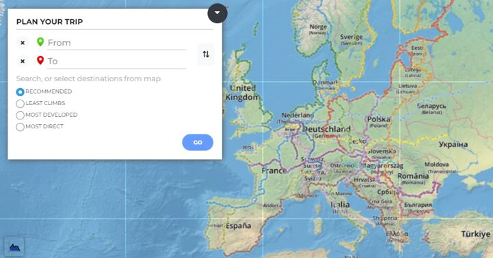
The first thing you will have to determine is where you want to start and end your trip along the network. You can type directly in the destination field to find the nearest city or town crossed by a EuroVelo route or pick a point on the map1. Do you want to visit a friend on the way or make a stop in that extraordinary city you always dreamt of discovering? No worries, just add an intermediate destination (or several) before diving into the different route options available to you!
We know that there are many different conceptions of what a cycling trip should be. Some will prefer the safest option with low-traffic roads, even if it means a longer journey, while others are looking to challenge themselves by covering many kilometres in a short period of time. There are adventure-seekers among you, but also people who just want to experience a slow travelling style. That is why you can choose among several options: the most developed itinerary, the most direct or the one which contains the least climbs. And rest assured, if you do not have a firm opinion on the topic, you can pick the recommended itinerary, delivering a perfect balance between all of those options.
A suggested itinerary and so much more
After making these first choices, click on “GO” and let the magic happen.
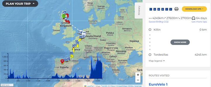
You will now see a focus on the calculated itinerary, with the different colours of the interactive map legend appearing to show the development levels you will find along the way2.
You can also pass your cursor on the itinerary to consult the elevation levels or directly go to the bottom-left corner to see the full elevation graphic. The different points of interest are indicated on the map as well, to give you an overview of the many cultural, culinary or historical sites you will cross (a non-exhaustive list!).

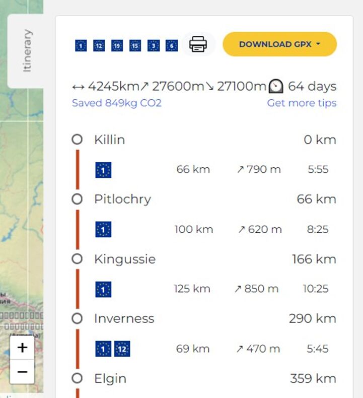
Check the “Itinerary” box on the right side of your screen to see more details about this planned trip. You can find the route logos of the EuroVelo routes covered, followed by the total number of kilometres of the itinerary and the approximate duration of the trip. Please note that the average number of kilometres cycled per day has been fixed to 50 kilometres, but you might shorten your trip by covering longer distances each day.
Just below is the amount of CO2 saved by making your trip on a bike, which you can brag about to those around you who are not yet convinced by cycling tourism (if there are still any!).

Another novelty that you will find in this box is our brand-new “Five tips to plan your cycling trip” page to help you further in the preparation for your cycling trip.
By clicking on "Show more”, all the suggested daily stages are unveiled, followed by descriptions of the different EuroVelo routes and information on countries and National EuroVelo Coordination Centres3.
Finally, you can go back to the top to print or save your itinerary in PDF but also download the GPX tracks of your selected itinerary (please read the disclaimer). If you are not sure how to use the GPX files, here is an article explaining how it works with a selection of apps and software programs that are easy to experiment.
Once accustomed, you can start over with other destinations and imagine an infinite number of cycling journeys!
A demonstration video on how to configure your route
For all the YouTube tutorial fans out there, we have prepared a short video to guide you through this new, exciting feature! As this Route Planner was developed in the frame of the AtlanticOnBike project, we imagined a trip along the magnificent EuroVelo 1 – Atlantic Coast Route. Click below to discover the tutorial.
Go on and start dreaming, as dreams are the prerequisite to making a new reality happen. The Route Planner is free to use, but if you like what we're doing, don't hesitate to support EuroVelo. If you notice any bugs when using the route planner, please let us know by emailing us at [email protected].


Cover picture: Gironde, La Vélodyssée, French section of EuroVelo 1– Atlantic Coast Route © Aurélie Stapf
Author: Alexandra Fournier, with contributions from Jessica Casagrande, Florence Grégoire and Mark Sheridan
1. Please keep in mind that you will have to select a place along one EuroVelo route for your starting, intermediary and ending point. This route planner is only using EuroVelo routes. You may have to use other local, regional or national cycling routes to join your starting destination along the EuroVelo network. If you would like to find out more about local, regional and national cycling routes, we invite you to browse the different countries’ pages containing all links to the relevant national websites.
2. Green lines indicate a Certified EuroVelo route meaning that either the full route or a section of at least 300 km has successfully undergone the certification process in line with the ECF's European Certification Standard. It is the highest quality level on the EuroVelo network. Yellow lines mean there is continuous signing along the route incorporating EuroVelo route information panels. Continuous red lines indicate that the route is signed in line with the respective national standard. For both latest categories, there must be a website providing more information to users (linked to EuroVelo.com). Dashed red lines indicate routes under development but usable. It means also it is possible to follow the route either with signing or detailed information publicly available on the internet on national or regional cycling/tourism portals (linked to EuroVelo.com). The route may contain some sections that need further development (e.g. stretches on public highways with high levels of traffic). Dotted red lines indicate routes at the planning stage. Therefore, the route is not signed and there is no detailed information publicly available on the Internet. The proposed itinerary communicated is a proposal for the best possible option currently available. Please note that it may also contain dangerous sections. Finally, white dotted lines show the sections for which another type of transport has to be used (mostly ferries and sometimes trains, and for some exceptions, planes due to ferry lines shut down). Please find more information on the stage and route pages. Please note that ECF is constantly working with its National EuroVelo Coordination Centres (NECC) on developing the network, but there remain differences in the conditions of the routes, even between sections of the same route. NECCs provide the latest information they have on development levels that can be found along the network. While ECF and National EuroVelo Coordination Centers (NECC) make every effort to ensure the tracks and their levels of development are both current and accurate, errors or outdated information can occur.
3. The National EuroVelo Coordination Centres (NECCs) represent the link between the European and national levels of EuroVelo routes. Most of the time, it is a consortium of several national stakeholders – often including decision-making bodies on transport and tourism. They are responsible for the implementation, coordination, quality assurance and communication of EuroVelo in their respective countries.